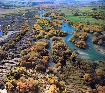
The Hundred Islands
During the early years of the gold-rush, log raftsman regularly guided large timber rafts down the Upper Clutha from Lake Wanaka to Lowburn, to supply much needed timber to the gold-fields. The gold-rush began on the Upper Clutha in August 1862 following Hartley and Reilly's strike in the Cromwell Gorge. Log rafting pioneer, George Hassing, described stranding a raft on one of the many shingle shoals in the reach below the Lindis River confluence, indicating that it was difficult to navigate.
From the Lindis River confluence to Deadman's Point near Cromwell, the Clutha was a braided river with various channels which suddenly converged at Deadman's Point, beyond which the already swift current accelerated down into the narrows of the Cromwell Gap Rapid.
The log-rafts were initally taken through to Clyde (Upper Dunstan) with the first one arriving on October 6, 1862. However, the Cromwell Gap was too perilous, so the rafts were subsequently landed at Lowburn. The current must have been formidable even there, because Hassing described the difficulty of securing a heavy raft to the bank before it could be swept passed Deadman's Point into the Crowwell Gap Rapid. One such raft, missing the landing-place, turned a complete somersault in the Gap.
The log-rafts were initally taken through to Clyde (Upper Dunstan) with the first one arriving on October 6, 1862. However, the Cromwell Gap was too perilous, so the rafts were subsequently landed at Lowburn. The current must have been formidable even there, because Hassing described the difficulty of securing a heavy raft to the bank before it could be swept passed Deadman's Point into the Crowwell Gap Rapid. One such raft, missing the landing-place, turned a complete somersault in the Gap.
Originally, the Clutha River between Deadman's Point and the Lindis River confluence was naturally braided, probably as the result of flood cycles washing river shingle down into the basin area around Lowburn. Overflowing banks would have spread the shingle and created new channels, but when the flow returned to normal it would again concentrate into fewer channels.
Gold-dredging companies later found this area relatively easy to work, because the extensive gold-bearing gravels could be excavated by cutting side channels away from the main river. Gold-dredging boomed first in the 1890's, and continued in the Lowburn area until 1963, when the NZ Austral-Malay, the largest gold-dredge ever built, ceased operation. As the gold-dredges worked, their tailing booms deposited rows of 'tailings'. Often, they would cut new channels, and eventually the tailings area expanded from Deadman's Point to well above Lowburn, particularly on the west side of the river. Later, willows colonised the margins wherever water flowed.
The upper area of shoals and braides below the Lindis River confluence was scarcely touched by gold-dredges, and that section downstream as far as the Dunstan reservoir - formed in 1993 behind the Clyde dam, remains relatively original apart from willow infestation.
The remaining area of shoals and braides was largely altered by gold-dredging, though the eastern side toward Bendigo retained many naturally formed islands and riverbanks. The entire braided river section contained over 100 islands, large and small, and was known as 'Sandy King's Islands' or simply the 'Hundred Islands.' Numerous back-pools provided safe places to swim, and the area was a favourite hideaway for Summer campers.
Prior to the filling of the reservoir behind the Clyde dam, the entire area from Deadman's Point to Bendigo was bulldozed. The willows were buried, much to the ire of the local community who considered this a waste of firewood. The small town of Lowburn by the Clutha was also bulldozed. The only building to be relocated was the church. The concrete bridge across the Clutha, and the roads, and even the roadside markers, remain under the reservoir.

