'I am loathe to believe that we will attach greater value to the sight of Lowburn Bay stocked to capacity with a few water skiers on the incoming weekend tide than we will to the enjoyment of hundreds at picnics on the shade-dappled grassy banks of the rolling Clutha at Bendigo, which must be one of the most beautiful stretches of flowing water in the world.' - K.F. O'Connor, Multiple Resource Use in the Upper Clutha Valley, Journal of Hydrology (NZ) Vol 14, No. 2, 1975.

Lowburn History

In the early settlement days of Central Otago, Lowburn was a prominent ferry landing for travellers moving between the goldmining reefs of Bendigo and the township of Cromwell.

There had been a Welcome Home Hotel in the area since 1865, when the first hotel was built by John and Charlotte Perriam on the Quartz Reef side of the river. In 1869, they completed a new stone hotel across the river in the growing settlement of Lowburn Ferry. Mrs Perriam became the proprietress in 1883 after the death of her husband. The stone hotel had thirteen bedrooms, three sitting-rooms, a bar, kitchen, and a dining-room that could seat twenty guests. There was a stable at the back and an adjoining store stocking general merchandise.


Welcome Home Hotel


The hotel was located on the main street facing the Clutha River. It was rebuilt and renovated a number of times, but retained many of its historic features and artifacts. The hotel was the headquarters of the Lowburn Curling Club and always had a colourful place in the community.

A ferry or punt began operating on the Clutha River at Lowburn from about 1873, and the crossing, with its tree-lined approaches and picturesque setting became not only an important link between Cromwell and the lakes at Wanaka and Queenstown, but also a popular tourist excursion.


Lowburn Ferry, circa 1920, by JH IngleyLowburn Ferry, circa 1920, by JH Ingley

Welcome Home Hotel

Welcome Home Hotel, circa 1880


There had been a Welcome Home Hotel in the area since 1865, when the first hotel was built by John and Charlotte Perriam on the Quartz Reef side of the river. In 1869, they completed a new stone hotel across the river in the growing settlement of Lowburn Ferry. Mrs Perriam became the proprietress in 1883 after the death of her husband. The stone hotel had thirteen bedrooms, three sitting-rooms, a bar, kitchen, and a dining-room that could seat twenty guests. There was a stable at the back and an adjoining store stocking general merchandise.

The building was located on the main street facing the Clutha River, where the Lowburn Ferry operated for 63 years until 1938, when a concrete arch bridge was built across the river. The hotel was rebuilt and renovated a number of times, but retained many of its historic features and artefacts. The hotel was the headquarters of the Lowburn Curling Club and always had a colourful place in the community.


Welcome Home Hotel, circa 1978


Welcome Home Hotel, 1984


1984 Sign

Lowburn Ferry

Lowburn Ferry, circa 1920


Lowburn Ferry, circa 1920, by JH IngleyLowburn Ferry, circa 1920, by JH Ingley

Sold Down The Reservoir

Welcome Home Hotel, 1978, with the first of two signs that would appear on the pub.
Photograph by Robin Morrison


The second sign, of a man having a beer through a snorkel, was put up in the 1980's ~
'In 198? this hospitable place could be 20 metres beneath the new Lake Dunstan.'


Signs placed on Lowburn's Welcome Home Hotel in the 1970s and 1980s voiced the stoic despair of a community facing inundation if, and when, the Clyde dam reservoir would be pronounced safe enough to fill.

In the lead up to the New Zealand elections in 1975, one aspiring candidate was Warren Cooper. There had been uncertainty over hydro dam plans on the Clutha for many years. Questioned at the Lowburn pub by Shorty Sutherland, a retired gold-miner who lived across the road, Mr Cooper promised not to flood Lowburn and the pub. Mr Cooper said: "If you want water in your whiskey, vote Labour."

In 1977, Warren Cooper MP, strode onto the recently constructed Clyde dam lookout, beyond which work had begun on the dam that would eventually flood the Cromwell Gorge, part of Cromwell and much of the Lowburn area including five orchards and the Lowburn pub, where he had made his earlier promise. He had come to address a protest group called "Clutha Rescue," who had set up camp at the lookout. Mr Cooper asked: "Why can't you support me over the construction of this dam?"

The building of the dam was opposed by five landowners at Lowburn and two in the Cromwell Gorge. They took their case against the Government to the High Court in Wellington, who ruled in their favour, determining that there was no end user for the power at Clyde and that the applicant had no water right.

But Prime Minister Robert Muldoon rallied his supporters. In the end legislation was passed with the help of the two Social Credit MP's. The Clutha Development (Clyde Dam) Empowering Act was enacted on the 30th of September 1982. All legal avenues for legitimate objection had been removed.

The Lowburn community had been cast aside, sold down the reservoir, lock stock and beer barrel. Outside the pub, a sign appeared showing a man having a drink wearing a snorkel. In 1988, the bulldozers arrived to demolish the hotel and 'reshape' the valley. The Welcome Home Hotel, the Motor Camp, the houses along the main street, the concrete arch bridge across the Clutha, the "hundred islands" with numerous popular campsites and swimming-holes, and some of the best farmland in the region, all disappeared into the pages of a bitter history.


Lowburn Valley after the Clyde damLowburn and the Clutha Valley after the Clyde dam


'In all the history of Otago and of New Zealand, in peace and in war, the Clutha proposals must rank as the cruellist and most premeditated. Conceived in departmental ambition, nourished in secrecy and permitted by political indifference for people, the Clutha proposals hardened into unpalatable fact.' ~ Paul Powell, 'Who Killed the Clutha?'

The Hundred Islands

During the early years of the gold-rush, log raftsman regularly guided large timber rafts down the Upper Clutha from Lake Wanaka to Lowburn, to supply much needed timber to the gold-fields. The gold-rush began on the Upper Clutha in August 1862 following Hartley and Reilly's strike in the Cromwell Gorge. Log rafting pioneer, George Hassing, described stranding a raft on one of the many shingle shoals in the reach below the Lindis River confluence, indicating that it was difficult to navigate.

From the Lindis River confluence to Deadman's Point near Cromwell, the Clutha was a braided river with various channels which suddenly converged at Deadman's Point, beyond which the already swift current accelerated down into the narrows of the Cromwell Gap Rapid.

The log-rafts were initally taken through to Clyde (Upper Dunstan) with the first one arriving on October 6, 1862. However, the Cromwell Gap was too perilous, so the rafts were subsequently landed at Lowburn. The current must have been formidable even there, because Hassing described the difficulty of securing a heavy raft to the bank before it could be swept passed Deadman's Point into the Crowwell Gap Rapid. One such raft, missing the landing-place, turned a complete somersault in the Gap.


The Hundred IslandsThe Hundred Islands


Originally, the Clutha River between Deadman's Point and the Lindis River confluence was naturally braided, probably as the result of flood cycles washing river shingle down into the basin area around Lowburn. Overflowing banks would have spread the shingle and created new channels, but when the flow returned to normal it would again concentrate into fewer channels.

Gold-dredging companies later found this area relatively easy to work, because the extensive gold-bearing gravels could be excavated by cutting side channels away from the main river. Gold-dredging boomed first in the 1890's, and continued in the Lowburn area until 1963, when the NZ Austral-Malay, the largest gold-dredge ever built, ceased operation. As the gold-dredges worked, their tailing booms deposited rows of 'tailings'. Often, they would cut new channels, and eventually the tailings area expanded from Deadman's Point to well above Lowburn, particularly on the west side of the river. Later, willows colonised the margins wherever water flowed.

The upper area of shoals and braides below the Lindis River confluence was scarcely touched by gold-dredges, and that section downstream as far as the Dunstan reservoir - formed in 1993 behind the Clyde dam, remains relatively original apart from willow infestation.

The remaining area of shoals and braides was largely altered by gold-dredging, though the eastern side toward Bendigo retained many naturally formed islands and riverbanks. The entire braided river section contained over 100 islands, large and small, and was known as 'Sandy King's Islands' or simply the 'Hundred Islands.' Numerous back-pools provided safe places to swim, and the area was a favourite hideaway for Summer campers.

Prior to the filling of the reservoir behind the Clyde dam, the entire area from Deadman's Point to Bendigo was bulldozed. The willows were buried, much to the ire of the local community who considered this a waste of firewood. The small town of Lowburn by the Clutha was also bulldozed. The only building to be relocated was the church. The concrete bridge across the Clutha, and the roads, and even the roadside markers, remain under the reservoir.

Lowburn Before The Clyde Dam

Pre-resevoir map showing original river course


View upriver over Lowburn, circa 1966

Deadman's Point Bridge

Deadman's Point Footbridge (second), 1926, by Albert Percy Godber


Deadman's Point holds a unique place in the history of the Clutha River, and of the Lowburn / Cromwell area. Here, the full force of the river suddenly converged into a narrow chasm at the beginning of the infamous Cromwell 'Gap'. Here, the first bridge spanned the river, and here countless gold-miners crossed and re-crossed en-route to their diggings, witnessing raging floods, and occasionally death in the vortexing waters of the 'Point'.


The first bridge across the Clutha River was erected at Deadman's Point by Henry Hill and opened in May, 1863. It was a footbridge suitable for packhorses, and it provided the shortest route for gold-miners heading to the strike on the Arrow River, which was then accessed via the Cardrona Valley. Prior to this bridge, gold-miners would continue upriver to Sandy Point, where they could cross on a ferry established by George Hassing and William Ellacott in March, 1863.

"The connection between Cromwell and the country lower down the Clutha River, was a pack-bridge erected over that river by Mr. Henry Hill. Wagons with stores and goods had to unload, and everything was packed across on horses." - Past & Present, and Men of the Times, by Captain William Jackson. Barry.

Hill's bridge, however, was swept away that Spring by a devastating flood that ripped away riverbanks, mining-camps, and buildings along the length of the river, claiming over a hundred lives.


The Second Deadman's Point Bridge In Flood


The Deadman's Point footbridge was eventually replaced (date unknown) by a well-built structure that survived subsequent floods. Although the footbridge was sited at the narrowest part of the river between Lowburn and Cromwell, the massive new traffic bridge, opened in 1866, was located at the Cromwell Junction directly adjoining Cromwell's main street, in order to facilitate traffic through the town.

The footbridge at Deadman's Point provided convenient foot and horse access to the diggings at Quartz Reef Point and Bendigo well into the 20th century.

Just how Deadman's Point acquired its name is unknown, but as the river at this point converged into a narrow precipitous 'gap' and surged with immense speed down a series of rapids to the Junction at Cromwell, it is likely that it was considered a 'point of no return'.

The reputation of the river was formidable, due in no small part to the perilous experiences of the log-raftsmen on the Upper Clutha. The log-rafting enterprise was started in 1862 by George Hassing and Henry Hill to supply much-needed lumber from the western forests to the virtually treeless interior. The first log-raft to negotiate the river as far as Clyde (Dunstan) arrived on October 6th, 1862.

"It was decided not to try and negotiate the gorge with these craft. They were navigated to a landing-place between Lowburn and Cromwell, but it was frequently a most difficult procedure to catch the landing-place. Once past it, there was absolutely no choice but to allow the raft to shoot through the roaring, rocky gorge above Cromwell. The raftsman had the alternative of either abandoning ship or of taking his chance aboard his craft. One man known as the Boatswain, having been caught in this predicament, took the consequences of remaining at the tiller. His raft, after entering the gorge, turned a complete somersault. He managed to climb aboard again and bring it into an eddy near the Kawarau Junction, where he was secured by a shore man - very wet, but grateful that he had escaped unhurt." - The Wanaka Story, by Irvine Roxburgh.


The Cromwell Gap, 1977, by Robin Morrison


The Deadman's Point footbridge had always provided the most direct access to Bendigo, but only for travellers on foot or horseback. Obviously, the new 1866 traffic bridge at Cromwell provided access for wagons and later motor vehicles, and in 1938 when the new concrete bridge was opened at Lowburn, the old footbridge at the 'Point' was used even less.

By the 1970s the footbridge was gone, and the Clutha River was the focus of evermore speculation over future dams. During the following decades, hydro plans came and went, but almost all of them doomed the productive river flats around Lowburn to inundation. The eventual plan included the destruction of old Cromwell and the construction of new roads, and a new bridge, at Deadman's Point. In a bitter twist of fate, the towering columns of the new bridge rose above the site of the original footbridge, connecting the new Cromwell centre with the east side of the gorge.


The 'New' Deadman's Point Bridge, before the 'Point' was flooded, circa 1990


Remarkably, Deadman's Point was not physically destroyed during the construction of the bridge. In the future, when the reservoir is decommissioned (it was planned to last 80 years) the 'Point' should be easily revealed when de-silted. By comparison, the distinctive Cromwell Junction, which was almost obliterated by earth-moving machinery prior to the filling of the reservoir, will be difficult to restore.


The 'New' Deadman's Point Bridge, after reservoir filling


Today, the 'new' Deadman's Point bridge stands high above the flooded 'Point', and few people who drive over it realize the significance of either the name, or the location.

The Lowburn Bridge

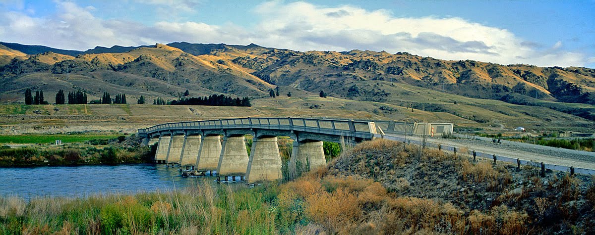
Opened in 1938 to replace the heavily used ferry, the Lowburn Bridge was constructed of concrete spans, forming a single-lane structure with an unusual arch. The approaches to the bridge on both sides were ramped with the possible intention of allowing floodwaters to pass around the bridge. The bridge was sited exactly where the ferry had been, with an avenue of trees on the western side leading directly to the nearby Welcome Home Hotel, at a 'T' intersection at the centre of Lowburn. Permanent homes and holiday houses were interspersed among the trees.


Lowburn Bridge, February 1992, after the trees and buildings were cleared


Prior to the filling of the Dunstan reservoir - in three stages between 1992-93, the Lowburn area was entirely cleared of trees and buildings, but the bridge was left. Before the waters rose a car was parked on the centre span of the bridge, and it still rests there today, submerged in the murky gloom, as a ghostly point of interest for divers.

About This Site

A brief history of Lowburn before the Clyde dam inundated the turquoise river, flooding our campsites, farms, and orchards. Where now, can we go to sit in the dappled shade beside the swift crystal waters, cooled by the moving air and the song of the river? Where is our river paradise? It is 60ft under.

  © Free Blogger Templates 'Photoblog II' by Ourblogtemplates.com 2008

Back to TOP